1. Overview
There are two basic kinds of climate data in DELPHIN:
-
Location data
-
Climate components (single climate data)
1.1. Location data
These data are intended to represent the climate at a particular location. They are combined in one file, which may contain the following climate components:
-
temperature
-
relative humidity
-
diffuse solar radiation on a horizontal surface
-
direct solar radiation
-
longwave atmospheric counter radiation
-
wind speed
-
wind direction
-
rain flow density
-
atmospheric pressure
Furthermore, this file must contain information about the location. These are e.g.:
-
country
-
city or location
-
longitude
-
latitude
-
altitude
DELPHIN normally uses climate files in its own format c6b. Furthermore files in epw and wac format can be read.
1.1.1. c6b format
The c6b format is a binary format which can contain all climate components mentioned above. There is also the possibility that single components can contain no or invalid data. For editing such files the free tool CCMEditor is available. This program can be downloaded here https://www.bauklimatik-dresden.de/downloads.php?aLa=en . With the help of this program the data can be changed or new data can be added. It can also read various other formats such as epw, wac, TRY 2017. There is also an import wizard for text via the clipboard with which other text-oriented formats can be read in (text files, Excel, etc.). In the c6b format the direct solar radiation is stored as solar normal radiation. If the original data contains the radiation on a horizontal surface, it will be converted, considering the geographical location. You can find an online help for this tool here: https://www.bauklimatik-dresden.de/ccmeditor/help/en/index.html.
1.1.2. epw format
EPW is the abbreviation for Energy Plus Weather. This format was developed in the USA primarily for use with the EnergyPlus software. However, it is now also used by a variety of other building simulation programs. It is a text-based format that contains the data as comma-separated columns. Here is an example of the beginning of such a file:

You can find a description for all elements of this format among others here: https://climate.onebuilding.org/papers/EnergyPlus_Weather_File_Format.pdf.
Both DELPHIN and the CCMEditor can read this format directly. But this is only possible if this file contains data for one year as hourly values. Different time periods are possible but rare. Files of this format normally also do not contain rain, which is why it is only conditionally suitable for hygrothermal calculations. In the following, the most important columns for DELPHIN are shown with the corresponding climate components:
-
0 - start year
-
6 - temperature
-
8 - relative humidity
-
9 - atmospheric pressure
-
12 - atmospheric sky irradiation
-
14 - direct solar radiation normal to the sun
-
15 - diffuse solar radiation on a horizontal surface
-
20 - wind direction
-
21 - wind speed
Columns 28 (precipitable water) or 32 (liquid precipitation depth) may contain rain.
1.1.3. wac format
The wac format (WUFI ASCII Climate) was developed by the Fraunhofer Institute for Building Physics in Holzkirchen (IBP) for data exchange with the software WUFI. It is a text format with flexible column structure. The columns are defined in the header. Here is an example:

The following columns are possible
-
ISGH - global solar radiation on the horizontal surface
-
ISDH - direct solar radiation on the horizontal surface
-
ISD - diffuse solar radiation on horizontal surface
-
ISM - measured short-wave radiation on a given surface
-
ILAH - atmospheric counter radiation on horizontal surface
-
ILTH - terrestrial longwave radiation on horizontal surface
-
ILM - measured longwave radiation impact on a given surface
-
CI - occultation
-
WS - scalar mean value of wind speed
-
WV - vectorial mean value of wind speed
-
WD - wind direction
-
RN - rain on horizontal surface in one hour
-
RM - measured rain flow on a given area
-
TA - ambient temperature
-
HREL - relative humidity
-
PSTA - air pressure at station height
-
PMSL - air pressure reduced to sea level
Since the wac format can contain rain, it is well suited as an interchange format. Furthermore, it can be generated by external tools like the Meteonorm software (https://meteonorm.com/) or the Lokalklimagenerator (https://wufi.de/de/2017/03/31/lokalklimagenerator/) of IBP.
1.2. Single climate data - climate components.
A climate component represents a single quantity. DELPHIN can use it as climate condition. Climate conditions can contain constant values, sinusoidal oscillations, external data sets, or external sources from an FMU. Climate conditions can be used in boundary conditions or field conditions.
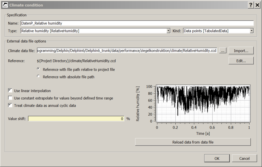
A climate condition can read the following types of datasets:
-
ccd format
-
tsv format
-
2D DELPHIN output files as d6o or d6b
1.2.1. ccd format
The ccd format represents a single climate component as a time series in a text file. The following format is used:
# comments
# comments
Keyword Unit
dd hh:mm:ss value
Here is an example of a temperature:
# Common file format
# Air temperatures
Temperature C
0 0:00:00 -2
0 6:00:00 -4
0 10:00:00 4
1 00:00:00 -1
1 6:00:00 -4
.
.
The keyword in the header is used by DELPHIN to check the correct usage of the climate file. In the following tables you will find all currently available keywords.
| Keyword | Explanation | Unit |
|---|---|---|
Temperature |
C |
RelativeHumidity |
relative humidity |
% |
VaporPressure |
Vapor Pressure |
Pa |
GasPressure |
AirPressure |
Pa |
RainFluxNormal |
Rain Flow Density Normal to Surface |
l/m2s |
RainFluxHorizontal |
Rain stream density on a horizontal surface |
l/m2s |
WindDirection |
Wind Direction |
Deg |
WindVelocity |
Wind Speed |
m/s |
SWRadiationImposed |
Shortwave Radiation Normal to Surface |
W/m2 |
SWRadiationDirect |
direct solar radiation to a horizontal surface |
W/m2 |
SWRadiationDiffuse |
diffuse solar radiation on a horizontal surface |
W/m2 |
LWRadiationFlux |
incident longwave radiation normal to the surface |
W/m2 |
CloudCoverage |
Occultation |
- |
SkyTemperature |
Sky Temperature |
C |
LWRadiationSkyEmission |
longwave sky counterradiation |
W/m2 |
LWRadiationGroundEmission |
| keyword | explanation | unit |
|---|---|---|
PressureHead |
PressureHead |
m |
SolutionConcentration |
Solution concentration for salt (molality) |
mol/kg |
WaterFlux |
Liquid Water Flow Normal to Surface |
kg/m2s |
HeatFlux |
Heat flux normal to the surface |
W/m2 |
VOCDensity |
VOC density in the gas phase (concentration) |
µg/m3 |
WaterSource |
Liquid Water Production Rate |
kg/m3s |
EnergySource |
Energy Source (Volume Source) |
W/m3 |
VOCSource |
VOC Source (Production Rate) |
mg/m3s |
FluidFlowRate |
Volume flow rate for liquids or gases |
m3/s |
MassFlowRate |
Mass Flow |
kg/s |
FluidChangeRate |
Change rate for liquids or gases (air change rate) |
1/s |
Percentage |
HeatTransferCoefficient |
Heat Transfer Coefficient |
W/m2K |
Power |
Power |
W |
Velocity |
Speed |
If a climate dataset with a wrong keyword is assigned in Delphin, only a warning will be issued and the simulation will not be aborted. Please watch out for yellow text in the solver window (warnings). Such incorrect assignments should be corrected, because otherwise wrong results can occur.
1.2.2. tsv format
A tsv file is a special form of the well known csv file. There are only tabs as separators and only numbers are allowed as data. For DELPHIN to handle such a file correctly, the following format should be used:
time [unit] value1 [unit] ...
Time value1
...
There can be multiple value columns. The time column must always be the first one. The unit must be specified. The text in the column header of the values can be arbitrary but should reflect the type of data. DELPHIN does not evaluate keywords here and cannot check the correct usage. Here is an example:
Time [d] Temperature [C]
0 -2
0.2 -4
0.5 4
1 -1
1.4 -4
.
.
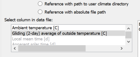
If more than one value column is specified, a selection box appears in the climate conditions dialog of DELPHIN (see below).
2. Use of climate data
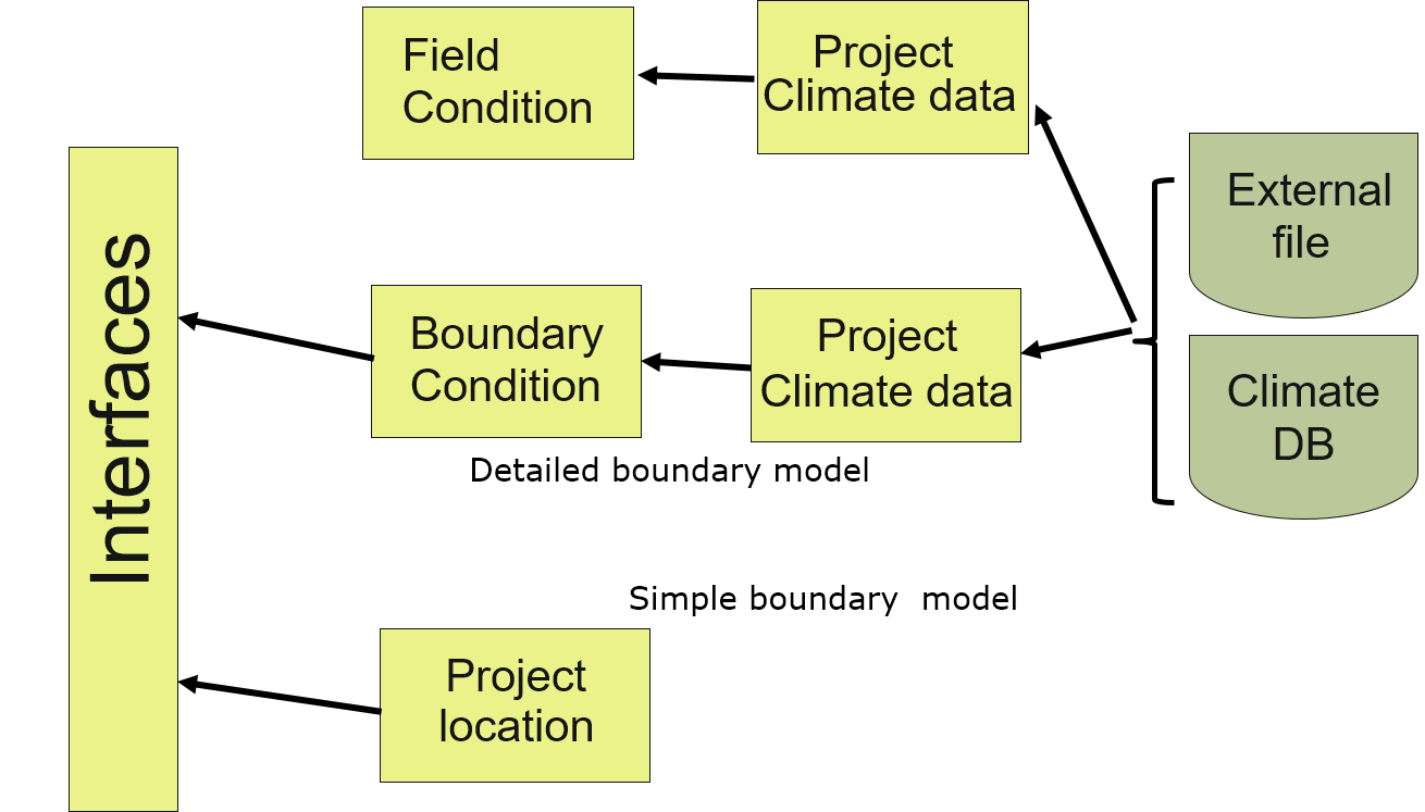
Climate data are used in DELPHIN in two places:
-
boundary conditions resp. surfaces
-
Field conditions or sources/sinks
There are two types of use:
direct use without specification - surfaces in simple mode implicitly use climate conditions without specifying it separately. For outdoor climate, site data is taken and for indoor climate, constant values are applied or climate data is calculated using a model (adaptive models).
Use with indication of used climate component - Here climate conditions are used, which in turn can be assigned to boundary conditions or field conditions.
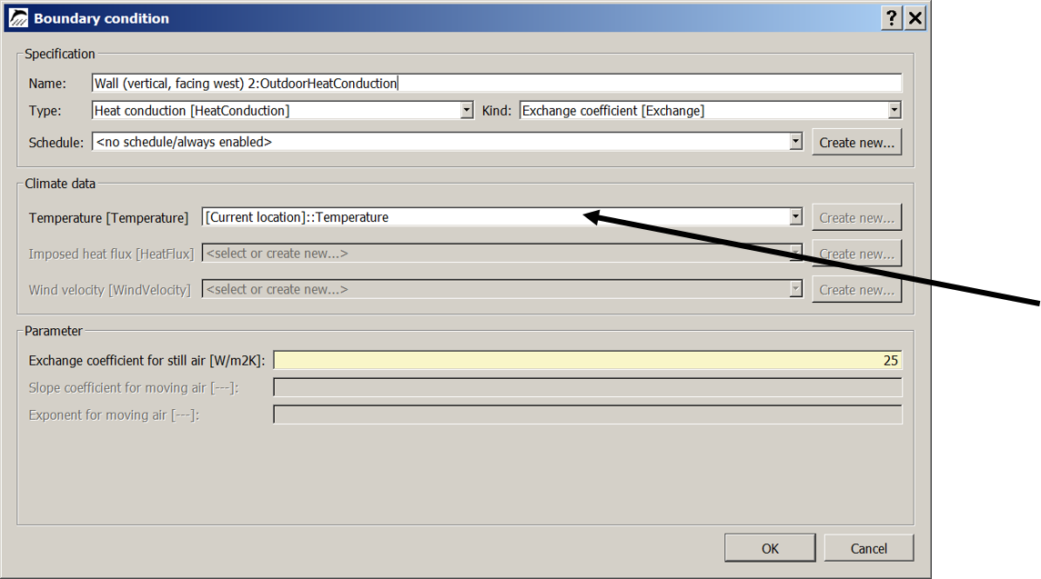
The location data can be used directly in DELPHIN without sparate generation of climate conditions. To do so, select a dataset from the climate selection list, which starts with the text '[Current location]::' (see picture below).
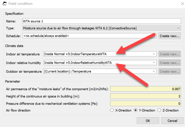
Since DELPHIN version 6.1.3, you can also access all datasets created in surfaces implicitly in this way. In this case, the name in the climate list is automatically composed of the name of the surface and a keyword. For example, in the image below, the dataset 'Inside Normal +5:IndoorTemperatureWTA' is used for the air temperature. This means:
-
the dataset is from a surface named 'Inside Normal +5 '
-
this surface is of type indoor climate with subtype adaptive climate according to WTA 6.2
-
it is a temperature
Furthermore, climate data can also be configured in a climate condition, which can then be selected in a boundary or field condition.
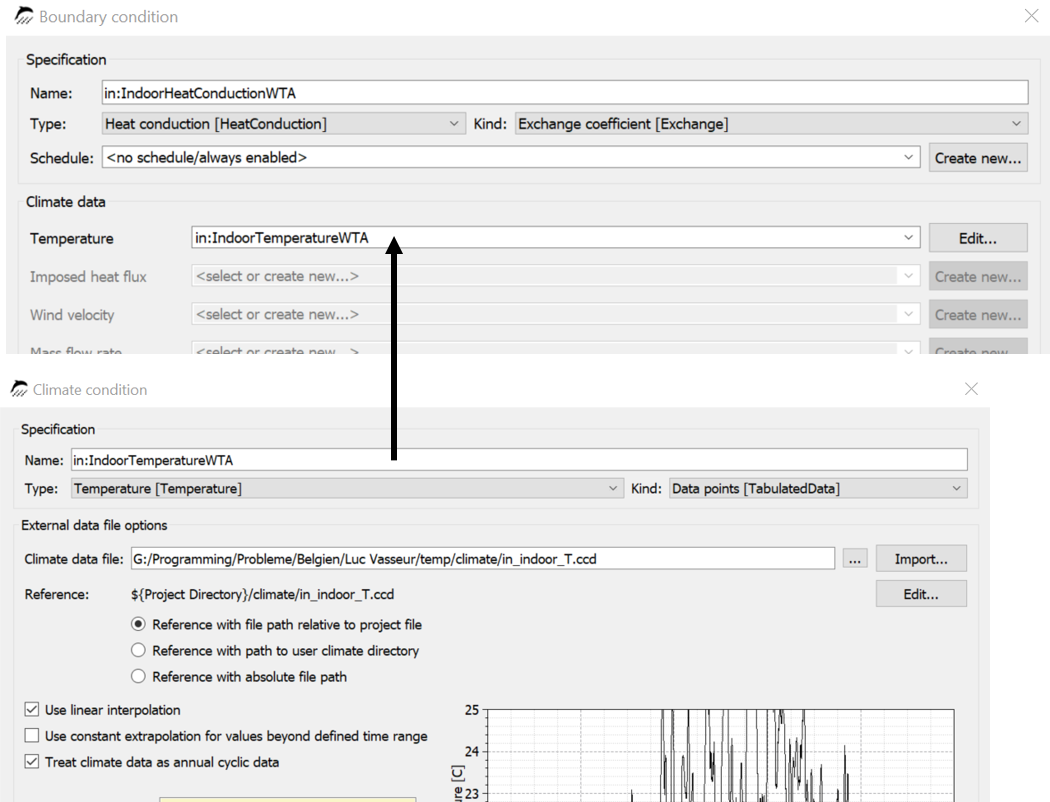
In the image above, a climate condition named 'in:IndoorTemperatureWTA' was created and then assigned to a boundary condition of type heat transfer as temperature. Such a boundary condition can then be used in a surface of the detailed type.
2.1. Climate conditions
A climate condition is a kind of container for climate data. The following types of data can be used here:
-
constant values
-
simple sine oscillation
-
two superimposed sine oscillations
-
data sets from external files
-
data transfer from a FMU (FMI coupling)
In principle, climate data from external files can be used in two ways:
-
cyclic application - climate data for one year can be repeated for any period.
-
non-cyclic application - data can be used only for the period in which they are given (mostly measured data).
When files are read in there are three types of links:
-
reference to the path relative to the DELPHIN project (project-related data)
-
reference to the path relative to the climate user database (database-related data)
-
absolute file path (no reference)

If the climate file cannot be read, an error message is displayed in the chart area of the climate condition.
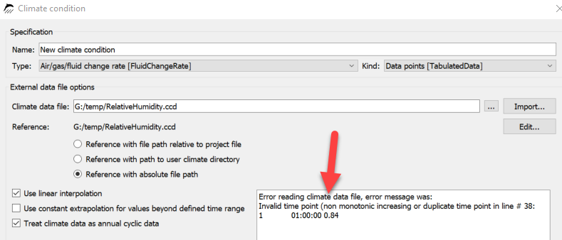
In the image above, the error message says that the time points are not monotonically increasing. An incorrect value was found in line 38. The file can then be corrected by clicking on the 'Edit' button in a text editor.
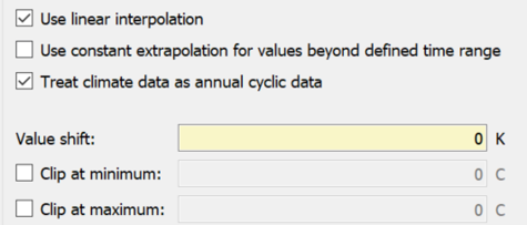
There are the following options:
-
use linear interpolation
-
for time values between two given points in time, the data is interpolated using a linear function.
-
otherwise the step function is used - not recommended
-
-
use constant extrapolation
-
if a time value is outside the given time range (only if not cyclic), the new value is created from the last value
-
otherwise the calculation aborts with an error message
-
-
treat climate data as annually cyclic
-
must be switched on, if the climate data set for one year with hourly values is available and the simulation is longer than one year
-
Switched off for non-cyclic data sets to avoid errors
-
-
Value shift
-
shifts the whole dataset by the specified value
-
can be used to create a simple extreme year
-
-
Clip at minimum or maximum
-
If this option is checked, the data will be truncated at the specified value
-
If tsv files with multiple value columns have been read in, a selection dialog appears to choose which data set to use.
3. Handling of location data
The following image shows the location data selection in DELPHIN.
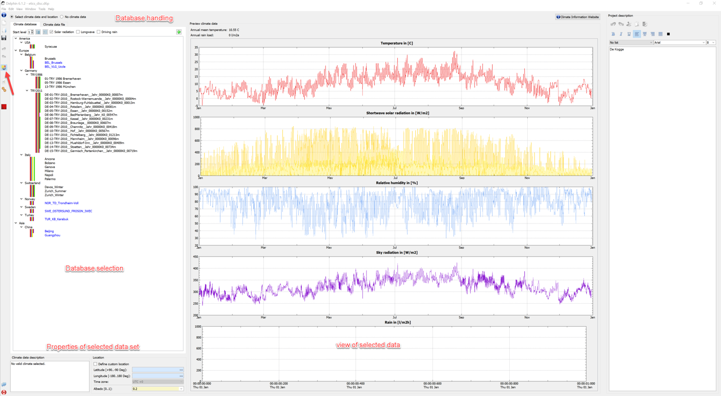
This view is displayed when you click on the button marked with the red arrow in DELPHIN. It is divided into several areas:
-
Database selection - tree view of the climate database for selection.
-
Database properties - changing the view, filtering
-
Properties of the selected dataset - geographic coordinates, comments
-
View - graphical representation of the most important data
In this view the following actions are possible:
-
Selection of a location dataset from the internal database or the user database.
-
Selection of an external file
-
Selection 'no climate data' for simulations without location data (e.g. recalculation of laboratory experiments).
-
Adding a dataset to the user climate database.
-
Editing the environment albedo
-
Assigning a design location that differs from the climate location
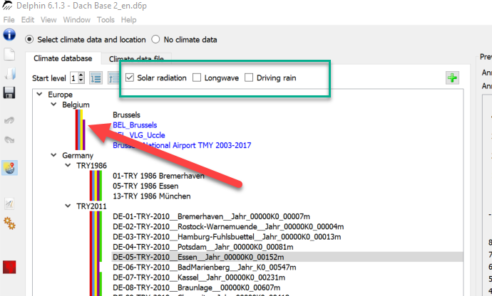
The selection tree shows all locations in the internal database (black) and the user database (blue). When an element is selected, the data is displayed in diagrams to the right of it. Here you can also quickly check if all data is available. In the upper area (green box) there are three checkboxes for filtering the tree. These buttons represent the solar radiation, the long wave radiation and the driving rain. If a box is checked, only those data are displayed that also contain the mentioned climate component. Another control possibility is given by the color boxes. Each color here represents a climate component:
-
Red - temperature
-
Blue - relative humidity
-
Yellow - short-wave solar radiation
-
Brown - long-wave sky radiation
-
Green - rain
You can also import location data from an external file. To do this, select the tab 'climate data file' at the top.

Here, as already described above, the formats c6b, epw and wac are possible. If the file can be read in, the data is displayed in the diagrams. There are two possibilities for the directory references:
-
relative path to the project - recommended.
-
absolute path
At the bottom of the selection dialog additional information and setting options can be found.

The left side shows a description of the selected climate if it is included in the corresponding file. The right side shows the following data:
-
The geographical data for the current climate location.
-
The albedo for the shortwave reflection of the surrounding ground
-
Selection field for specifying own coordinates
Normally, the displayed geographical coordinates correspond to the climate location (reference location or climate station). The corresponding fields then have a blue background, indicating that this data cannot be changed. If the selection field 'Define custom location' is selected, the background becomes yellow and the data can be changed. This allows you to specify your own locations for the construction to be calculated. This mainly affects the sun position calculations. This can also lead to the fact that sunrise and sunset no longer fit to the climate data. I.e. according to the sun position the sun may have already risen, but the radiation data are still at zero. Therefore this option should not be used if possible.
3.1. Adding data to the user database
If location data from external sources are used frequently, it is recommended to add them to the user database. First click on the green plus button.
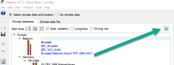
Then a dialog (wizard) for adding climate data opens.
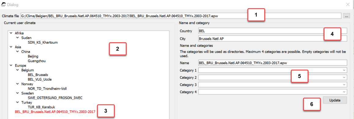
One proceeds as follows:
-
Selection of the climate file in dialog box 1
-
Specification of country and city in the fields at 4
-
Tree diagram 2 shows the classification of the new climate data set in the structure
-
Adjusting the classification structure by specifying categories and edit name at 5
-
Click on the button 'Update' at 6 shows the updated tree structure.
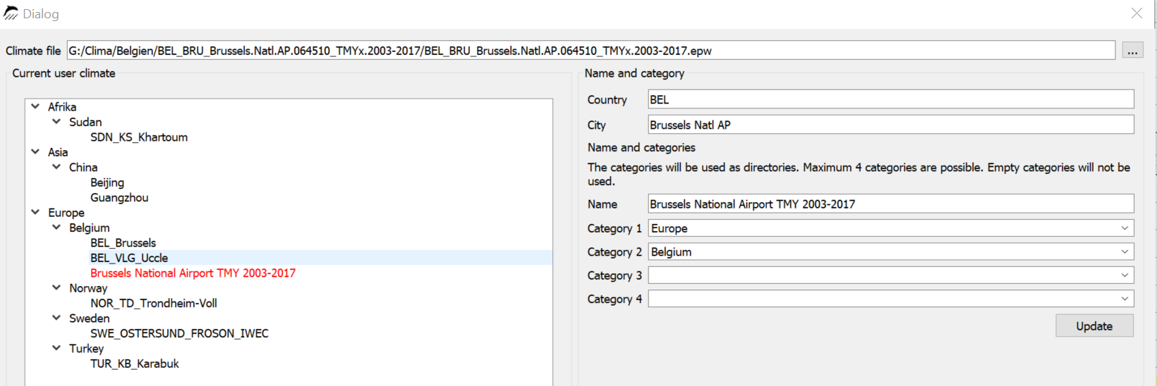
-
Finish by clicking on 'Ok'.
Since version 6.1.3, the climate data view is also updated afterwards and the new file is displayed. As formats are again c6b, epw and wac possible. If the file has another format, it must be converted before with the help of the CCMEditor.
4. Conclusion
More information about climate data can be found on our website:
There is also explained how the data of the new German test reference year 2017 can be included. However, since these data do not contain rain, they can only be used for hygrothermal simulations to a limited extent.
Furthermore there is our forum: Forum-FAQ_Climate